
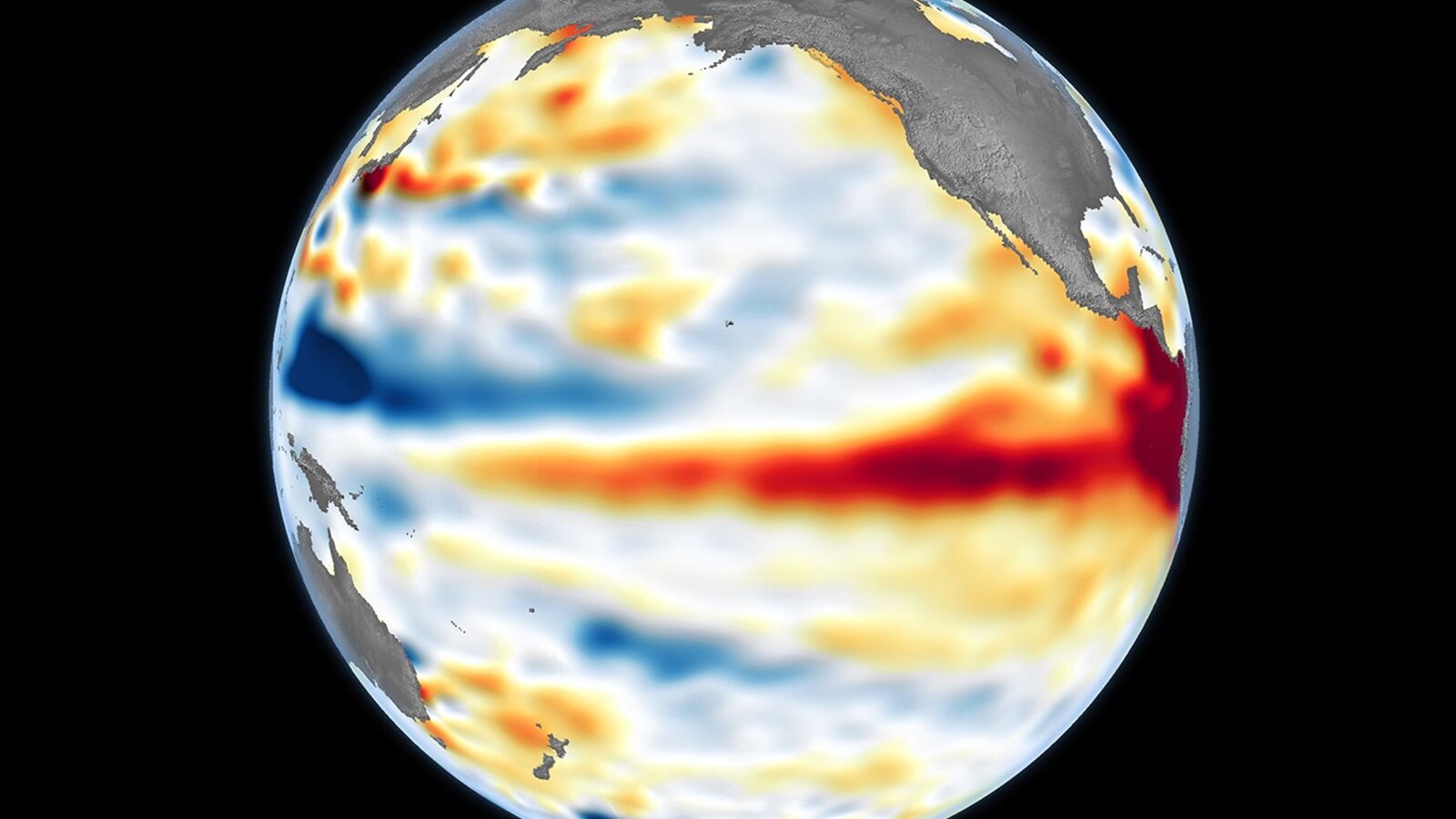
The global climate story of 2026 is shifting from a hot summer to a larger question: whether the oceans have stored enough heat to push this year, and almost certainly next year, toward new temperature records.
Associated Press reported this week that 2026 is not yet the hottest year in modern records, ranking behind 2024 and 2025 so far. But the margin is narrowing as a rapidly strengthening El Nino builds in the tropical Pacific, marine heatwaves spread across much of the global ocean, and forecasters warn that the strongest effects may not arrive until late 2026 and early 2027.
That timing matters. El Nino does not instantly appear in global surface-temperature rankings. Warm water first accumulates in the Pacific, then transfers heat into the atmosphere over several months. The present concern is that the ocean signal is already unusually strong before the main atmospheric impact has fully arrived.
Why The Warning Changed
NOAA declared El Nino conditions in June after sea surface temperatures in the central and eastern equatorial Pacific stayed at least 0.5 degrees Celsius above average for several consecutive months. Its Climate Prediction Center has since said El Nino is present, is expected to strengthen through the end of the year, and has a very high chance of lasting into early spring 2027.
The official forecast is important because stronger El Nino events can tilt rainfall, temperature, drought, and storm patterns across several continents. They do not guarantee the same impact everywhere, but they increase the odds of familiar disruptions: wetter conditions in parts of the southern United States and western South America, drier conditions in Indonesia and Australia, and altered tropical cyclone patterns across ocean basins.
NASA’s satellite record gives another reason for caution. Sentinel-6 Michael Freilich observed higher-than-normal sea surfaces across the central and eastern Pacific on June 8, shortly before NOAA’s declaration. NASA Earth Observatory said sea surface height is a useful sign of ocean heat because warm water expands. In June, that elevated water pointed to a growing subsurface heat reservoir, not just a temporary warm skin at the surface.
Oceans Are Driving The Risk
The oceans cover more than 70 percent of Earth, so sustained ocean heat can reshape the global average. It also affects fisheries, coral reefs, coastal storms, rainfall patterns, and the amount of energy available to tropical weather systems.
Copernicus Marine Service reported that June 2026 produced record global sea surface temperatures for the month, with persistent ocean warmth and expanding marine heatwaves across the first half of the year. AP, citing Europe’s Copernicus climate service, reported that marine heatwaves affected about 82 percent of the world’s ocean surface this year.
That does not mean every coastline feels the same effect. Marine heatwaves vary by basin and depth, and local winds, currents, and upwelling can still create sharp regional differences. But the breadth of the signal makes the El Nino forecast more consequential because the Pacific event is forming on top of oceans that are already unusually warm.
The result is a stacked risk. Human-driven warming raises the background temperature. El Nino then adds a temporary natural boost. The ocean lag means the hottest global months may come after people have already endured a difficult summer of fires, heatwaves, and drought stress.
Food Security Is Becoming A Central Concern
The global implications extend beyond temperature rankings. The Guardian reported Thursday that the World Food Programme is warning a strong El Nino could push tens of millions more people into acute hunger before the end of next year if rainfall failures and crop losses hit vulnerable regions.
The food-risk map is broad. Southern Africa can face drought stress during strong El Nino episodes. Parts of South and Southeast Asia can see disrupted rainfall patterns that matter for rice and other staple crops. Central America, the Caribbean, and parts of South America can face changes in rainfall, storms, or harvest conditions.
Those risks are not isolated from politics and markets. Food systems are already under pressure from conflict, debt burdens, high logistics costs, and climate-related disasters. When a strong El Nino arrives in that environment, the question is not only whether rainfall fails, but whether governments, aid agencies, and households have enough room to absorb another shock.
Early-warning systems can reduce losses if they trigger action before crops fail or herds weaken. That means pre-positioning food, protecting water supplies, helping farmers adjust planting decisions, and financing emergency support before distress turns into displacement or hunger.
What Scientists Are Watching Next
The next key signals will come from the tropical Pacific. Forecasters will track the Nino 3.4 sea surface temperature region, trade winds, pressure patterns, Kelvin waves, and the coupling between ocean and atmosphere. A strong ocean anomaly matters most when atmospheric circulation locks in and reinforces it.
NOAA’s next seasonal updates will show whether the event is continuing toward the very strong range. NASA and JPL satellite observations will keep showing whether elevated sea surface height in the Pacific is being sustained or refreshed by new pulses of warm water.
Global temperature data will also be watched month by month. The year-to-date ranking can change quickly when ocean heat is released into the atmosphere, especially if late-year months break monthly records. Even if 2026 does not pass 2024, scientists quoted by AP said 2027 is highly likely to challenge or exceed existing heat records because El Nino’s global temperature influence usually peaks after the event has matured.
What This Means Now
For governments, the message is preparedness rather than surprise. El Nino is a known climate pattern, but this one is developing in a hotter world and over unusually warm oceans. That combination raises the cost of waiting for impacts to become visible.
For readers, the practical takeaway is that the most important climate news may arrive in stages. A summer that is not yet record-setting can still be a warning if the oceans are storing heat, the Pacific is strengthening, and the humanitarian consequences are lining up months ahead.
The same global climate system has already shaped recent stories on Europe’s Danube drought and energy-market pressure around the Strait of Hormuz. El Nino adds another layer because it can redirect rainfall, amplify heat, and stress food systems across borders at the same time.
The records will be decided later. The preparation window is open now.